Region: HAW
All
Survey Types: Species & Abundance, Species Only
Dates: 1/1/93 - 6/19/26
Total Surveys: 2
#Species Reported: 30
Average Species Reported on a Survey by Expert Surveyors: 0
Average Species Reported on a Survey by Novice Surveyors: 19.00
Survey Type: SA = Species & Abundance; SO = Species Only - How to interpret REEF data?
Click a column header to sort by that column. Hold shift and click to sort by multiple columns
| Surveys | Bottom Time | |||||
|---|---|---|---|---|---|---|
| Expert | Novice | |||||
| Code | Name | SA | SO | SA | SO | (H:M) |
| 4 | Maui County (Maui, Lanai, Molokai, and Kahoolawe) | 0 | 0 | 2 | 0 | 1:15 |
| 41 | Maui | 0 | 0 | 2 | 0 | 1:15 |
| 4101 | Leeward Shore Maui (Honolua Bay - Cape Hanamanoia) | 0 | 0 | 2 | 0 | 1:15 |
| 410102 | South Maui (McGregor Pt. - Cape Hanamanoia) | 0 | 0 | 2 | 0 | 1:15 |
| 41010209 | Taape Reef | 0 | 0 | 2 | 0 | 1:15 |
| TOTALS | 0 | 0 | 2 | 0 | 1:15 | |
Species
%SF = Sighting Frequency; DEN = Density Score - How to interpret REEF data?
Bar length corresponds to sighting frequency
Color saturation corresponds to density score
Click + to display species image and additional information.
Bar length corresponds to sighting frequency
Color saturation corresponds to density score
Click + to display species image and additional information.
Bird Wrasse - Wrasse
(Gomphosus varius)
(Gomphosus varius)
Manybar Goatfish - Goatfish
(Parupeneus multifasciatus)
(Parupeneus multifasciatus)
Moorish Idol - Moorish Idol
(Zanclus cornutus)
(Zanclus cornutus)
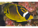
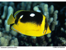
Raccoon Butterflyfish - Butterflyfish
(Chaetodon lunula)
(Chaetodon lunula)
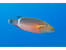
Saddle Wrasse - Wrasse
(Thalassoma duperrey)
(Thalassoma duperrey)

Spotted Puffer - Pufferfish
(Arothron meleagris)
(Arothron meleagris)

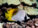
Threadfin Butterflyfish - Butterflyfish
(Chaetodon auriga)
(Chaetodon auriga)
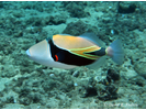
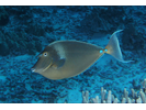
Wedgetail Triggerfish (aka Reef Triggerfish) - Triggerfish
(Rhinecanthus rectangulus)
(Rhinecanthus rectangulus)
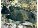
Barred Filefish - Filefish
(Cantherhines dumerili)
(Cantherhines dumerili)
Black Durgon (aka Black Triggerfish) - Triggerfish
(Melichthys niger)
(Melichthys niger)
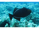
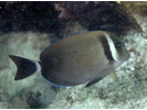
Black Surgeonfish - Surgeonfish
(Ctenochaetus hawaiiensis)
(Ctenochaetus hawaiiensis)
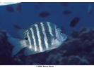
Blackspot Sergeant - Damselfish
(Abudefduf sordidus)
(Abudefduf sordidus)
Bluefin Trevally - Jack
(Caranx melampygus)
(Caranx melampygus)

Bluespine Unicornfish - Surgeonfish
(Naso unicornis)
(Naso unicornis)
Cornetfish (aka Bluespotted Cornetfish) - Cornetfish
(Fistularia commersonii)
(Fistularia commersonii)

Elegant Coris - Wrasse
(Coris venusta)
(Coris venusta)
Fourspot Butterflyfish - Butterflyfish
(Chaetodon quadrimaculatus)
(Chaetodon quadrimaculatus)
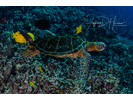
Green Sea Turtle - Sea Turtles
(Chelonia mydas)
(Chelonia mydas)
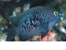
Hawaiian Gregory - Damselfish
(Stegastes marginatus)
(Stegastes marginatus)
Hawaiian Sergeant - Damselfish
(Abudefduf abdominalis)
(Abudefduf abdominalis)

Hawaiian Whitespotted Toby - Pufferfish
(Canthigaster jactator)
(Canthigaster jactator)

Orangespine Unicornfish - Surgeonfish
(Naso lituratus)
(Naso lituratus)
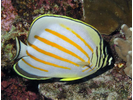
Ornate Butterflyfish - Butterflyfish
(Chaetodon ornatissimus)
(Chaetodon ornatissimus)
Oval Chromis - Damselfish
(Chromis ovalis)
(Chromis ovalis)
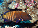
Peacock Grouper - Seabass
(Cephalopholis argus)
(Cephalopholis argus)
Redbarred Hawkfish - Hawkfish
(Cirrhitops fasciatus)
(Cirrhitops fasciatus)

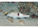
Ringtail Wrasse - Wrasse
(Oxycheilinus unifasciatus)
(Oxycheilinus unifasciatus)
Sidespot Goatfish - Goatfish
(Parupeneus pleurostigma)
(Parupeneus pleurostigma)
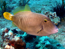
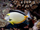
Whitebar Surgeonfish - Surgeonfish
(Acanthurus leucopareius)
(Acanthurus leucopareius)
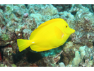
Yellow Tang - Surgeonfish
(Zebrasoma flavescens)
(Zebrasoma flavescens)