Region: HAW
All
Survey Types: Species & Abundance, Species Only
Dates: 1/1/93 - 6/18/26
Total Surveys: 6
#Species Reported: 30
Average Species Reported on a Survey by Expert Surveyors: 7.00
Average Species Reported on a Survey by Novice Surveyors: 8.80
Survey Type: SA = Species & Abundance; SO = Species Only - How to interpret REEF data?
Click a column header to sort by that column. Hold shift and click to sort by multiple columns
| Surveys | Bottom Time | |||||
|---|---|---|---|---|---|---|
| Expert | Novice | |||||
| Code | Name | SA | SO | SA | SO | (H:M) |
| 4 | Maui County (Maui, Lanai, Molokai, and Kahoolawe) | 1 | 0 | 5 | 0 | 3:50 |
| 41 | Maui | 1 | 0 | 5 | 0 | 3:50 |
| 4101 | Leeward Shore Maui (Honolua Bay - Cape Hanamanoia) | 1 | 0 | 5 | 0 | 3:50 |
| 410102 | South Maui (McGregor Pt. - Cape Hanamanoia) | 1 | 0 | 5 | 0 | 3:50 |
| 41010258 | Ko'ie'ie / Kalepolepo Fishpond | 1 | 0 | 5 | 0 | 3:50 |
| TOTALS | 1 | 0 | 5 | 0 | 3:50 | |
Species
%SF = Sighting Frequency; DEN = Density Score - How to interpret REEF data?
Bar length corresponds to sighting frequency
Color saturation corresponds to density score
Click + to display species image and additional information.
Bar length corresponds to sighting frequency
Color saturation corresponds to density score
Click + to display species image and additional information.
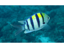
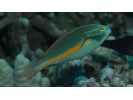
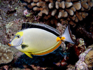
Convict Tang - Surgeonfish
(Acanthurus triostegus)
(Acanthurus triostegus)

Hawaiian Sergeant - Damselfish
(Abudefduf abdominalis)
(Abudefduf abdominalis)

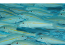
Hawaiian Silversides - Silversides
(Atherinomorus insularum)
(Atherinomorus insularum)
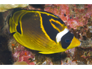
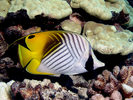
Raccoon Butterflyfish - Butterflyfish
(Chaetodon lunula)
(Chaetodon lunula)
Blackspot Sergeant - Damselfish
(Abudefduf sordidus)
(Abudefduf sordidus)
Hawaiian Gregory - Damselfish
(Stegastes marginatus)
(Stegastes marginatus)
Indo-Pacific Sergeant - Damselfish
(Abudefduf vaigiensis)
(Abudefduf vaigiensis)
Threadfin Butterflyfish - Butterflyfish
(Chaetodon auriga)
(Chaetodon auriga)
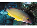
Whitesaddle Goatfish - Goatfish
(Parupeneus porphyreus)
(Parupeneus porphyreus)
Yellowfin Surgeonfish - Surgeonfish
(Acanthurus xanthopterus)
(Acanthurus xanthopterus)
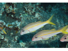
Yellowstripe Goatfish (aka Squarespot Goatfish) - Goatfish
(Mulloidichthys flavolineatus)
(Mulloidichthys flavolineatus)
Ambon Toby - Pufferfish
(Canthigaster amboinensis)
(Canthigaster amboinensis)
Belted Wrasse - Wrasse
(Stethojulis balteata)
(Stethojulis balteata)
Blacktail Snapper - Snapper
(Lutjanus fulvus)
(Lutjanus fulvus)
Bluefin Trevally - Jack
(Caranx melampygus)
(Caranx melampygus)

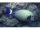
Brown Surgeonfish (aka Lavender Tang) - Surgeonfish
(Acanthurus nigrofuscus)
(Acanthurus nigrofuscus)

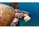
Green Sea Turtle w/ FP - Sea Turtles
(Chelonia mydas)
(Chelonia mydas)
Hawaiian Flagtail - Flagtail
(Kuhlia xenura)
(Kuhlia xenura)
Hawaiian Squirrelfish - Squirrelfish
(Sargocentron xantherythrum)
(Sargocentron xantherythrum)
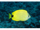
Milletseed Butterflyfish - Butterflyfish
(Chaetodon miliaris)
(Chaetodon miliaris)
Orangespine Unicornfish - Surgeonfish
(Naso lituratus)
(Naso lituratus)
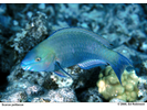
Palenose Parrotfish - Parrotfish
(Scarus psittacus)
(Scarus psittacus)
Ringtail Surgeonfish - Surgeonfish
(Acanthurus blochii)
(Acanthurus blochii)
Saddle Wrasse - Wrasse
(Thalassoma duperrey)
(Thalassoma duperrey)

Sharpnose Mullet - Mullet
(Neomyxus leuciscus)
(Neomyxus leuciscus)
Snowflake Moray - Moray
(Echidna nebulosa)
(Echidna nebulosa)
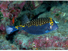
Spotted Boxfish - Boxfish
(Ostracion meleagris)
(Ostracion meleagris)
Spotted Puffer - Pufferfish
(Arothron meleagris)
(Arothron meleagris)

Twospot Sandgoby - Goby
(Fusigobius duospilus)
(Fusigobius duospilus)
Yellowfin Goatfish - Goatfish
(Mulloidichthys vanicolensis)
(Mulloidichthys vanicolensis)