Region: NE
All
Survey Types: Fish Only, Invertebrates Only, Fish & Invertebrates
Dates: 1/1/93 - 7/25/26
Total Surveys: 385
#Species Reported: 94
Average Species Reported on a Survey by Expert Surveyors: 9.70
Average Species Reported on a Survey by Novice Surveyors: 6.25
Survey Type: FO = Fish Only; IO = Invertebrates Only; FI = Fish & Invertebrates - How to interpret REEF data?
Click a column header to sort by that column. Hold shift and click to sort by multiple columns
| Surveys | Bottom Time | |||||||
|---|---|---|---|---|---|---|---|---|
| Expert | Novice | |||||||
| Code | Name | FO | IO | FI | FO | IO | FI | (H:M) |
| 9 | US & CANADA EAST COAST (Newfoundland thru Virginia) | 0 | 0 | 10 | 246 | 8 | 121 | 288:29 |
| 91 | NE US (Maine thru New York/Hudson Canyon) | 0 | 0 | 10 | 246 | 8 | 121 | 288:29 |
| 9101 | Massachusetts | 0 | 0 | 10 | 246 | 8 | 121 | 288:29 |
| 910108 | Massachusetts Bay (n. of Minot - Magnolia) | 0 | 0 | 10 | 246 | 8 | 121 | 288:29 |
| 91010801 | Magnolia Rocks (Magnolia) | 0 | 0 | 0 | 28 | 0 | 2 | 26:29 |
| 91010802 | Romance Wreck | 0 | 0 | 0 | 3 | 0 | 4 | 3:02 |
| 91010803 | Halfway Rock (Gloucester, Cape Ann) | 0 | 0 | 1 | 30 | 0 | 6 | 29:11 |
| 91010804 | Great Egg Rock (near Gloucester) | 0 | 0 | 0 | 8 | 0 | 2 | 8:10 |
| 91010805 | Wollaston Beach (Quincy Bay) | 0 | 0 | 0 | 2 | 0 | 0 | 1:05 |
| 91010806 | Newcomb Ledge | 0 | 0 | 0 | 2 | 0 | 0 | 1:08 |
| 91010807 | House Island | 0 | 0 | 0 | 4 | 0 | 1 | 4:03 |
| 91010808 | Satan Rock | 0 | 0 | 0 | 16 | 0 | 5 | 16:22 |
| 91010809 | Kettle Island | 0 | 0 | 1 | 23 | 0 | 6 | 22:38 |
| 91010810 | Never Fail Ledge | 0 | 0 | 0 | 3 | 0 | 3 | 3:46 |
| 91010811 | Boohoo Ledge | 0 | 0 | 0 | 3 | 0 | 2 | 3:50 |
| 91010812 | Outer Brewster Island | 0 | 0 | 1 | 7 | 0 | 6 | 8:46 |
| 91010813 | Saddle Rock | 0 | 0 | 0 | 2 | 0 | 0 | 1:53 |
| 91010814 | Salt Rock | 0 | 0 | 0 | 7 | 0 | 4 | 8:34 |
| 91010815 | Popplestone Beach | 0 | 0 | 0 | 16 | 0 | 9 | 18:42 |
| 91010816 | Thatcher Island (Manchester) | 0 | 0 | 0 | 1 | 0 | 0 | 0:47 |
| 91010817 | Cat / Children's Island (Marblehead) | 0 | 0 | 0 | 15 | 0 | 2 | 12:35 |
| 91010818 | Egg Rock (near Nahant) | 0 | 0 | 0 | 13 | 0 | 0 | 11:55 |
| 91010819 | Graves Light / Graves Lighthouse | 0 | 0 | 1 | 9 | 0 | 10 | 14:04 |
| 91010820 | Forty Steps - 40 Steps, Nahant | 0 | 0 | 0 | 2 | 0 | 0 | 1:23 |
| 91010821 | Sargent Road (Marblehead) | 0 | 0 | 0 | 7 | 0 | 0 | 5:43 |
| 91010823 | White Beach, near Manchester | 0 | 0 | 4 | 5 | 0 | 9 | 14:26 |
| 91010824 | Juniper Pt. Beach, Salem | 0 | 0 | 0 | 16 | 1 | 14 | 23:02 |
| 91010825 | Shag Rocks, Nahant | 0 | 0 | 0 | 3 | 0 | 0 | 1:46 |
| 91010826 | Pumphouse Beach, Nahant | 0 | 0 | 0 | 1 | 5 | 6 | 5:16 |
| 91010827 | Dive Beach, Nahant | 0 | 0 | 0 | 4 | 0 | 1 | 2:36 |
| 91010828 | Wreck of the Kiowa | 0 | 0 | 0 | 0 | 0 | 2 | 1:06 |
| 91010829 | Chandler Hovey Lighthouse, Marblehead | 0 | 0 | 0 | 2 | 0 | 6 | 6:33 |
| 91010831 | Fort Sewell, Marblehead | 0 | 0 | 0 | 5 | 0 | 2 | 6:03 |
| 91010832 | Marblehead Rock | 0 | 0 | 0 | 3 | 0 | 0 | 2:15 |
| 91010833 | Gun Rock Beach | 0 | 0 | 2 | 2 | 0 | 3 | 7:40 |
| 91010834 | East Point (Nahant) | 0 | 0 | 0 | 1 | 0 | 0 | 0:50 |
| 91010835 | Big Fantastic Wall | 0 | 0 | 0 | 1 | 0 | 0 | 0:40 |
| 91010836 | Cormorant Rock | 0 | 0 | 0 | 1 | 0 | 2 | 2:50 |
| 91010837 | Palmer Cove Yacht Club | 0 | 0 | 0 | 0 | 0 | 1 | 0:40 |
| 91010838 | Calf Island | 0 | 0 | 0 | 0 | 0 | 6 | 3:41 |
| 91010840 | Mingo Beach (Beverly) | 0 | 0 | 0 | 0 | 0 | 1 | 1:07 |
| 91010843 | Canoe Beach / Chimneys (Nahant) | 0 | 0 | 0 | 0 | 0 | 6 | 2:05 |
| 91010844 | Winthrop Beach (between Neptune and Mermaid Ave) | 0 | 0 | 0 | 0 | 2 | 0 | 1:10 |
| TOTALS | 0 | 0 | 10 | 246 | 8 | 121 | 288:29 | |
Species
%SF = Sighting Frequency; DEN = Density Score - How to interpret REEF data?
Bar length corresponds to sighting frequency
Color saturation corresponds to density score
Click + to display species image and additional information.
Bar length corresponds to sighting frequency
Color saturation corresponds to density score
Click + to display species image and additional information.
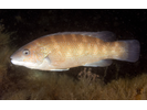
Cunner - Wrasse
(Tautogolabrus adspersus)
(Tautogolabrus adspersus)
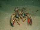
American Lobster - Arthropods
(Homarus americanus)
(Homarus americanus)
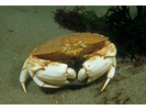
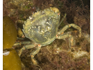
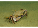
Atlantic Rock Crab - Arthropods
(Cancer irroratus)
(Cancer irroratus)

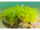
Sea Lettuce - Marine Plants and Algae
(Ulva sp.)
(Ulva sp.)
Jonah Crab - Arthropods
(Cancer borealis)
(Cancer borealis)
Invasive Didemnum Tunicate - Urochordates
(Didemnum vexillum)
(Didemnum vexillum)
Orange Sheath Tunicate - Urochordates
(Botrylloides violaceus)
(Botrylloides violaceus)

Blood Star - Echinoderms
(Henricia sanguinolenta)
(Henricia sanguinolenta)
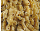
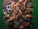
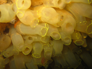
Blue Mussel - Mollusks
(Mytilus edulis)
(Mytilus edulis)
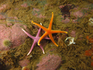
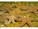
Forbes' Sea Star - Echinoderms
(Asterias forbesi)
(Asterias forbesi)
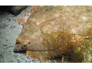
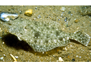
Winter Flounder - Flounder (Right-Eye)
(Pseudopleuronectes americanus)
(Pseudopleuronectes americanus)
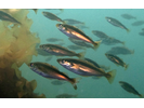
Pollock - Cod
(Pollachius virens)
(Pollachius virens)
Club Tunicate - Urochordates
(Styela clava)
(Styela clava)
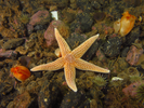
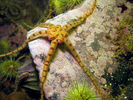
Northern Sea Star - Echinoderms
(Asterias rubens)
(Asterias rubens)
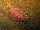
Rough Barnacle - Arthropods
(Balanus balanus)
(Balanus balanus)
Sea Lace - Bryozoans
(Membranipora membranacea)
(Membranipora membranacea)
Moon Snail - Mollusks
(Euspira heros)
(Euspira heros)
Spiral Tufted Bryozoan - Bryozoans
(Bugula turrita)
(Bugula turrita)
Green Sea Urchin - Echinoderms
(Strongylocentrotus droebachiensis)
(Strongylocentrotus droebachiensis)
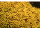
Boring Sponge - Poriferans
(Cliona celata)
(Cliona celata)
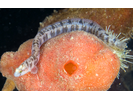
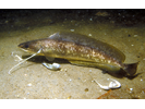
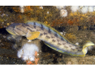
Rock Gunnel - Gunnel
(Pholis gunnellus)
(Pholis gunnellus)
Tautog - Wrasse
(Tautoga onitis)
(Tautoga onitis)
Green Crab - Arthropods
(Carcinus maenus)
(Carcinus maenus)
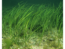
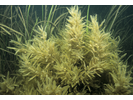
Eel Grass - Marine Plants and Algae
(Zostera marina)
(Zostera marina)
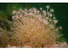
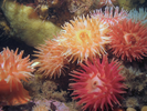
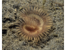
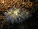
Frilled Anemone - Cnidarians
(Metridium senile)
(Metridium senile)
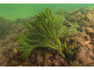
Green Fleece - Marine Plants and Algae
(Codium fragile)
(Codium fragile)
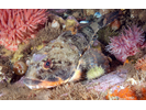
Grubby Sculpin - Marine Sculpin
(Myoxocephalus aenaeus)
(Myoxocephalus aenaeus)

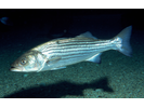
Striped Bass - Temperate Perch
(Morone saxatilis)
(Morone saxatilis)
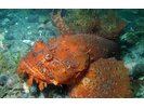
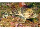
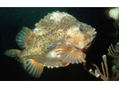
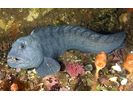
Sea Raven - Marine Sculpin
(Hemitripterus americanus)
(Hemitripterus americanus)
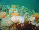
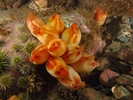
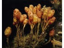
Golden Star Tunicate - Urochordates
(Botryllus schlosseri)
(Botryllus schlosseri)
Finger Sponge - Poriferans
(Haliclona oculata)
(Haliclona oculata)

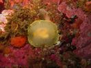
Sea Scallop - Mollusks
(Placopectin magellanicus)
(Placopectin magellanicus)

Tubularian Hydroid - Cnidarians
(Ectopleura crocea)
(Ectopleura crocea)
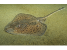
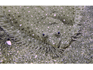
Winter Skate - Skate
(Leucoraja ocellata)
(Leucoraja ocellata)
Atlantic Cod - Cod
(Gadus morhua)
(Gadus morhua)
Sea Vase - Urochordates
(Ciona intestinalis)
(Ciona intestinalis)
Shorthorn Sculpin - Marine Sculpin
(Myoxocephalus scorpius)
(Myoxocephalus scorpius)
Northern Red Anemone - Cnidarians
(Urticina felina)
(Urticina felina)
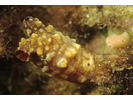
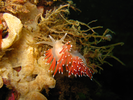
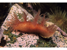
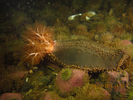
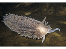
Red-Gilled Nudibranch - Mollusks
(Flabellina verrucosa)
(Flabellina verrucosa)
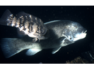
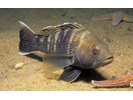
Black Sea Bass - Seabass
(Centropristis striata)
(Centropristis striata)
Sea Peach - Urochordates
(Halocynthia pyriformis)
(Halocynthia pyriformis)
Radiated Shanny - Prickleback
(Ulvaria subbifurcata)
(Ulvaria subbifurcata)
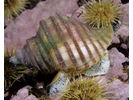
Mottled Chiton / Red Chiton - Mollusks
(Tonicella sp.)
(Tonicella sp.)
Sabellid Worm - Annelids
(Sabella sp.)
(Sabella sp.)
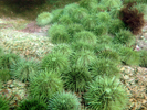
Sargassum Weed - Marine Plants and Algae
(Sargassum filipendula)
(Sargassum filipendula)
Bushy-Backed Nudibranch - Mollusks
(Dendronotus frondosus)
(Dendronotus frondosus)
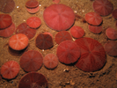
Common Sand Dollar - Echinoderms
(Echinarachnius parma)
(Echinarachnius parma)
Dead Man's Fingers - Cnidarians
(Alcyonium digitatum)
(Alcyonium digitatum)
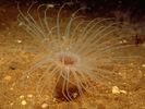
Northern Cerianthid - Cnidarians
(Synarachnactis lloydii)
(Synarachnactis lloydii)
Longhorn Sculpin - Marine Sculpin
(Myoxocephalus octodecemspinosus)
(Myoxocephalus octodecemspinosus)
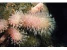
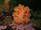
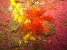
Sea Strawberry Soft Coral - Cnidarians
(Gersemia rubiformis)
(Gersemia rubiformis)
Little Skate - Skate
(Leucoraja erinacea)
(Leucoraja erinacea)
Summer Flounder - Flounder
(Paralichthys dentatus)
(Paralichthys dentatus)
Daisy Brittle Star - Echinoderms
(Ophiopholis aculeata)
(Ophiopholis aculeata)
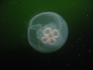
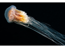
Moon Jelly - Cnidarians
(Aurelia aurita)
(Aurelia aurita)
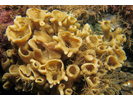
Northern Star Coral - Cnidarians
(Astrangia poculata)
(Astrangia poculata)
Lumpfish - Lumpfish & Snailfish
(Cyclopterus lumpus)
(Cyclopterus lumpus)
Chalice Sponge - Poriferans
(Phakellia ventilabrum)
(Phakellia ventilabrum)
Slime Worm - Annelids
(Myxicola infundibulum)
(Myxicola infundibulum)
Red (Squirrel) Hake - Cod
(Urophycis chuss)
(Urophycis chuss)
Unidentified Skate sp. - Skate
(Leucoraja sp.)
(Leucoraja sp.)
Ocellate Lady Crab - Arthropods
(Ovalipes ocellatus)
(Ovalipes ocellatus)
Skeleton Shrimp - Arthropods
(Caprella sp.)
(Caprella sp.)
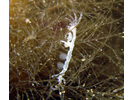
Northern Pipefish - Pipefish & Seahorse
(Syngnathus fuscus)
(Syngnathus fuscus)
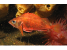
Acadian Redfish - Scorpionfish
(Sebastes fasciatus)
(Sebastes fasciatus)
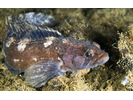
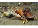
Ocean Pout - Eelpout
(Macrozoarces americanus)
(Macrozoarces americanus)
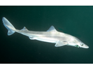
Spiny Dogfish - Dogfish
(Squalus acanthias)
(Squalus acanthias)
Windowpane Flounder - Flounder
(Scophthalmus aquosus)
(Scophthalmus aquosus)
Lion's Mane Jelly - Cnidarians
(Cyanea capillata)
(Cyanea capillata)
Longfin Inshore Squid - Mollusks
(Loligo pealeii)
(Loligo pealeii)

Scarlet Psolus - Echinoderms
(Psolus fabricii)
(Psolus fabricii)
Stalked Tunicate - Urochordates
(Boltenia ovifera)
(Boltenia ovifera)
White Cadlina / Yellow Cadlina - Mollusks
(Cadlina laevis / Cadlina luteomarginata)
(Cadlina laevis / Cadlina luteomarginata)
Bluefish - Bluefish
(Pomatomus saltatrix)
(Pomatomus saltatrix)
Unidentified Redfish - Scorpionfish
(Sebastes sp.)
(Sebastes sp.)
Arctic Shanny - Prickleback
(Stichaeus punctatus punctatus)
(Stichaeus punctatus punctatus)
Northern Searobin - Searobin
(Prionotus carolinus)
(Prionotus carolinus)
Spotted Hake - Cod
(Urophycis regia)
(Urophycis regia)
Witch Flounder - Flounder (Right-Eye)
(Glyptocephalus cynoglossus)
(Glyptocephalus cynoglossus)
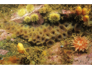
Orange-Footed Sea Cucumber - Echinoderms
(Cucumaria frondosa)
(Cucumaria frondosa)
Shag-Rug Aeolis - Mollusks
(Aeolidia papillosa)
(Aeolidia papillosa)
Wrinkle Whelk - Mollusks
(Neptunea lyrata decemcostata)
(Neptunea lyrata decemcostata)
Atlantic Silversides - Neotropical Silversides
(Menidia menidia)
(Menidia menidia)
Atlantic Wolffish - Wolffish
(Anarhichas lupus)
(Anarhichas lupus)
Clearnose Skate - Skate
(Leucoraja eglanteria)
(Leucoraja eglanteria)
Thorny Skate - Skate
(Amblyraja radiata)
(Amblyraja radiata)
American Eel - Eel (Freshwater)
(Anguilla rostrata)
(Anguilla rostrata)
Atlantic Herring - Herring
(Clupea harengus)
(Clupea harengus)
Butterfish - Butterfishes
(Peprilus triacanthus)
(Peprilus triacanthus)
Haddock - Cod
(Melanogrammus aeglefinus)
(Melanogrammus aeglefinus)
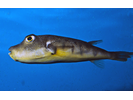
Northern Puffer - Puffer
(Sphoeroides maculatus)
(Sphoeroides maculatus)
Smooth Dogfish - Dogfish
(Mustelus canis)
(Mustelus canis)
Unidentified Shanny - Prickleback
(Stichaeidae)
(Stichaeidae)
Yellowtail Flounder - Flounder (Right-Eye)
(Limanda ferruginea)
(Limanda ferruginea)