Region: NE
All
Survey Types: Fish Only, Invertebrates Only, Fish & Invertebrates
Dates: 1/1/93 - 6/22/26
Total Surveys: 2
#Species Reported: 25
Average Species Reported on a Survey by Expert Surveyors: 21.00
Average Species Reported on a Survey by Novice Surveyors: 9.00
Survey Type: FO = Fish Only; IO = Invertebrates Only; FI = Fish & Invertebrates - How to interpret REEF data?
Click a column header to sort by that column. Hold shift and click to sort by multiple columns
| Surveys | Bottom Time | |||||||
|---|---|---|---|---|---|---|---|---|
| Expert | Novice | |||||||
| Code | Name | FO | IO | FI | FO | IO | FI | (H:M) |
| 9 | US & CANADA EAST COAST (Newfoundland thru Virginia) | 0 | 0 | 1 | 1 | 0 | 0 | 1:55 |
| 91 | NE US (Maine thru New York/Hudson Canyon) | 0 | 0 | 1 | 1 | 0 | 0 | 1:55 |
| 9104 | Rhode Island | 0 | 0 | 1 | 1 | 0 | 0 | 1:55 |
| 910401 | Avondale - Pt. Judith | 0 | 0 | 1 | 1 | 0 | 0 | 1:55 |
| 91040110 | Wreck of the Grecian | 0 | 0 | 1 | 1 | 0 | 0 | 1:55 |
| TOTALS | 0 | 0 | 1 | 1 | 0 | 0 | 1:55 | |
Species
%SF = Sighting Frequency; DEN = Density Score - How to interpret REEF data?
Bar length corresponds to sighting frequency
Color saturation corresponds to density score
Click + to display species image and additional information.
Bar length corresponds to sighting frequency
Color saturation corresponds to density score
Click + to display species image and additional information.
Blood Star - Echinoderms
(Henricia sanguinolenta)
(Henricia sanguinolenta)
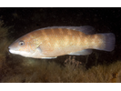
Cunner - Wrasse
(Tautogolabrus adspersus)
(Tautogolabrus adspersus)
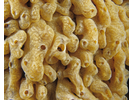
Dead Man's Fingers - Cnidarians
(Alcyonium digitatum)
(Alcyonium digitatum)
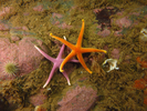
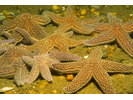
Forbes' Sea Star - Echinoderms
(Asterias forbesi)
(Asterias forbesi)
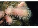
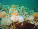
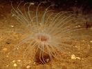
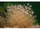
Frilled Anemone - Cnidarians
(Metridium senile)
(Metridium senile)
Invasive Didemnum Tunicate - Urochordates
(Didemnum vexillum)
(Didemnum vexillum)
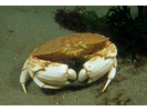
Jonah Crab - Arthropods
(Cancer borealis)
(Cancer borealis)
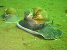
Moon Snail - Mollusks
(Euspira heros)
(Euspira heros)
Northern Cerianthid - Cnidarians
(Synarachnactis lloydii)
(Synarachnactis lloydii)
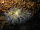
Northern Star Coral - Cnidarians
(Astrangia poculata)
(Astrangia poculata)
Red (Squirrel) Hake - Cod
(Urophycis chuss)
(Urophycis chuss)
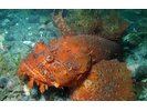
Sea Raven - Marine Sculpin
(Hemitripterus americanus)
(Hemitripterus americanus)
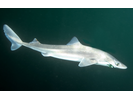
Spiny Dogfish - Dogfish
(Squalus acanthias)
(Squalus acanthias)
Tubularian Hydroid - Cnidarians
(Ectopleura crocea)
(Ectopleura crocea)
Winter Flounder - Flounder (Right-Eye)
(Pseudopleuronectes americanus)
(Pseudopleuronectes americanus)
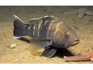
Atlantic Cod - Cod
(Gadus morhua)
(Gadus morhua)
Atlantic Tomcod - Cod
(Microgadus tomcod)
(Microgadus tomcod)
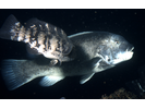
Black Sea Bass - Seabass
(Centropristis striata)
(Centropristis striata)
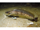
Conger Eel - Conger
(Conger oceanicus)
(Conger oceanicus)
Goosefish - Goosefish
(Lophius americanus)
(Lophius americanus)
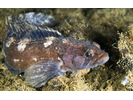
Ocean Pout - Eelpout
(Macrozoarces americanus)
(Macrozoarces americanus)
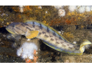
Radiated Shanny - Prickleback
(Ulvaria subbifurcata)
(Ulvaria subbifurcata)
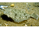
Summer Flounder - Flounder
(Paralichthys dentatus)
(Paralichthys dentatus)
Tautog - Wrasse
(Tautoga onitis)
(Tautoga onitis)
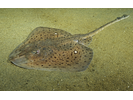
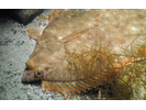
Winter Skate - Skate
(Leucoraja ocellata)
(Leucoraja ocellata)