Region: NE
All
Survey Types: Fish Only, Invertebrates Only, Fish & Invertebrates
Dates: 1/1/93 - 8/3/26
Total Surveys: 2
#Species Reported: 5
Average Species Reported on a Survey by Expert Surveyors: 0
Average Species Reported on a Survey by Novice Surveyors: 2.50
Survey Type: FO = Fish Only; IO = Invertebrates Only; FI = Fish & Invertebrates - How to interpret REEF data?
Click a column header to sort by that column. Hold shift and click to sort by multiple columns
| Surveys | Bottom Time | |||||||
|---|---|---|---|---|---|---|---|---|
| Expert | Novice | |||||||
| Code | Name | FO | IO | FI | FO | IO | FI | (H:M) |
| 9 | US & CANADA EAST COAST (Newfoundland thru Virginia) | 0 | 0 | 0 | 2 | 0 | 0 | 0:51 |
| 91 | NE US (Maine thru New York/Hudson Canyon) | 0 | 0 | 0 | 2 | 0 | 0 | 0:51 |
| 9104 | Rhode Island | 0 | 0 | 0 | 2 | 0 | 0 | 0:51 |
| 910405 | Conanicut, Prudence, and smaller islands | 0 | 0 | 0 | 2 | 0 | 0 | 0:51 |
| 91040509 | Jamestown Harbor | 0 | 0 | 0 | 2 | 0 | 0 | 0:51 |
| TOTALS | 0 | 0 | 0 | 2 | 0 | 0 | 0:51 | |
Species
%SF = Sighting Frequency; DEN = Density Score - How to interpret REEF data?
Bar length corresponds to sighting frequency
Color saturation corresponds to density score
Click + to display species image and additional information.
Bar length corresponds to sighting frequency
Color saturation corresponds to density score
Click + to display species image and additional information.
Grubby Sculpin - Marine Sculpin
(Myoxocephalus aenaeus)
(Myoxocephalus aenaeus)

Northern Pipefish - Pipefish & Seahorse
(Syngnathus fuscus)
(Syngnathus fuscus)
Silver Hake - Cod
(Merluccius bilinearis)
(Merluccius bilinearis)
Spotted Hake - Cod
(Urophycis regia)
(Urophycis regia)
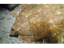
Winter Flounder - Flounder (Right-Eye)
(Pseudopleuronectes americanus)
(Pseudopleuronectes americanus)