Region: PAC
All
Survey Types: Fish Only, Invertebrates Only, Fish & Invertebrates
Dates: 1/1/93 - 6/30/26
Total Surveys: 1
#Species Reported: 22
Average Species Reported on a Survey by Expert Surveyors: 0
Average Species Reported on a Survey by Novice Surveyors: 22.00
Survey Type: FO = Fish Only; IO = Invertebrates Only; FI = Fish & Invertebrates - How to interpret REEF data?
Click a column header to sort by that column. Hold shift and click to sort by multiple columns
| Surveys | Bottom Time | |||||||
|---|---|---|---|---|---|---|---|---|
| Expert | Novice | |||||||
| Code | Name | FO | IO | FI | FO | IO | FI | (H:M) |
| 1 | British Columbia | 0 | 0 | 0 | 0 | 0 | 1 | 0:34 |
| 13 | STRAIT OF GEORGIA | 0 | 0 | 0 | 0 | 0 | 1 | 0:34 |
| 133 | S. Qualicum Beach - Nanaimo | 0 | 0 | 0 | 0 | 0 | 1 | 0:34 |
| 1334 | Wallis Point - Dorcas Point and islands | 0 | 0 | 0 | 0 | 0 | 1 | 0:34 |
| 13340005 | Abandonment Pinnacle (btw Ada & Southey Isls) | 0 | 0 | 0 | 0 | 0 | 1 | 0:34 |
| TOTALS | 0 | 0 | 0 | 0 | 0 | 1 | 0:34 | |
Species
%SF = Sighting Frequency; DEN = Density Score - How to interpret REEF data?
Bar length corresponds to sighting frequency
Color saturation corresponds to density score
Click + to display species image and additional information.
Bar length corresponds to sighting frequency
Color saturation corresponds to density score
Click + to display species image and additional information.
Blackeye Goby - Goby
(Rhinogobiops nicholsii)
(Rhinogobiops nicholsii)

California Sea Cucumber - Echinoderms
(Parastichopus californicus)
(Parastichopus californicus)

Chimney Sponge - Poriferans
(Rhabdocalyptus dawsoni/Staurocalyptus dowlingi)
(Rhabdocalyptus dawsoni/Staurocalyptus dowlingi)

Copper Rockfish - Scorpionfish
(Sebastes caurinus)
(Sebastes caurinus)

Gumboot Chiton - Mollusks
(Cryptochiton stelleri)
(Cryptochiton stelleri)

Juvenile (YOY) Rockfish - Unidentified - Scorpionfish
(Sebastes sp. (YOY))
(Sebastes sp. (YOY))

Kelp Greenling - Greenling
(Hexagrammos decagrammus)
(Hexagrammos decagrammus)

Lingcod - Greenling
(Ophiodon elongatus)
(Ophiodon elongatus)

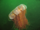
Lion's Mane Jelly - Cnidarians
(Cyanea capillata)
(Cyanea capillata)
Northern Abalone - Mollusks
(Haliotis kamtschatkana)
(Haliotis kamtschatkana)

Northern Ronquil - Ronquil
(Ronquilus jordani)
(Ronquilus jordani)

Orange Cup Coral - Cnidarians
(Balanophyllia elegans)
(Balanophyllia elegans)

Orange Sea Pen - Cnidarians
(Ptilosarcus gurneyi)
(Ptilosarcus gurneyi)

Orange Social Ascidian - Urochordates
(Metandrocarpa taylori)
(Metandrocarpa taylori)

Painted Greenling - Greenling
(Oxylebius pictus)
(Oxylebius pictus)

Plumose Anemone - Cnidarians
(Metridium farcimen / senile)
(Metridium farcimen / senile)

Quillback Rockfish - Scorpionfish
(Sebastes maliger)
(Sebastes maliger)

Shiny Orange Sea Squirt - Urochordates
(Cnemidocarpa finmarkiensis)
(Cnemidocarpa finmarkiensis)

Spiny Pink Star - Echinoderms
(Pisaster brevispinus)
(Pisaster brevispinus)

Sunflower Star - Echinoderms
(Pycnopodia helianthoides)
(Pycnopodia helianthoides)

Tiger Rockfish - Scorpionfish
(Sebastes nigrocinctus)
(Sebastes nigrocinctus)

Unidentified Sculpin - Marine Sculpins
(Psychrolutidae spp.)
(Psychrolutidae spp.)