Region: PAC
All
Survey Types: Fish Only, Invertebrates Only, Fish & Invertebrates
Dates: 1/1/93 - 6/23/26
Total Surveys: 3
#Species Reported: 21
Average Species Reported on a Survey by Expert Surveyors: 14.50
Average Species Reported on a Survey by Novice Surveyors: 7.00
Survey Type: FO = Fish Only; IO = Invertebrates Only; FI = Fish & Invertebrates - How to interpret REEF data?
Click a column header to sort by that column. Hold shift and click to sort by multiple columns
| Surveys | Bottom Time | |||||||
|---|---|---|---|---|---|---|---|---|
| Expert | Novice | |||||||
| Code | Name | FO | IO | FI | FO | IO | FI | (H:M) |
| 1 | British Columbia | 0 | 0 | 2 | 0 | 0 | 1 | 2:20 |
| 13 | STRAIT OF GEORGIA | 0 | 0 | 2 | 0 | 0 | 1 | 2:20 |
| 136 | Howe Sound | 0 | 0 | 2 | 0 | 0 | 1 | 2:20 |
| 1369 | Burrard Inlet | 0 | 0 | 2 | 0 | 0 | 1 | 2:20 |
| 136901 | Indian Arm | 0 | 0 | 2 | 0 | 0 | 1 | 2:20 |
| 13690105 | Wreck of the VT-100 | 0 | 0 | 2 | 0 | 0 | 1 | 2:20 |
| TOTALS | 0 | 0 | 2 | 0 | 0 | 1 | 2:20 | |
Species
%SF = Sighting Frequency; DEN = Density Score - How to interpret REEF data?
Bar length corresponds to sighting frequency
Color saturation corresponds to density score
Click + to display species image and additional information.
Bar length corresponds to sighting frequency
Color saturation corresponds to density score
Click + to display species image and additional information.
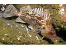
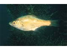
Brown Rockfish - Scorpionfish
(Sebastes auriculatus)
(Sebastes auriculatus)
Lingcod - Greenling
(Ophiodon elongatus)
(Ophiodon elongatus)

Plumose Anemone - Cnidarians
(Metridium farcimen / senile)
(Metridium farcimen / senile)

White-lined Dirona - Mollusks
(Dirona albolineata)
(Dirona albolineata)

California Sea Cucumber - Echinoderms
(Parastichopus californicus)
(Parastichopus californicus)

Copper Rockfish - Scorpionfish
(Sebastes caurinus)
(Sebastes caurinus)

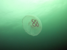
Moon Jelly - Cnidarians
(Aurelia labiata)
(Aurelia labiata)
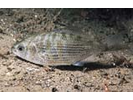
Pile Perch - Surfperch
(Rhacochilus vacca)
(Rhacochilus vacca)

Shiner Perch - Surfperch
(Cymatogaster aggregata)
(Cymatogaster aggregata)
Striped Seaperch - Surfperch
(Embiotoca lateralis)
(Embiotoca lateralis)

Sunflower Star - Echinoderms
(Pycnopodia helianthoides)
(Pycnopodia helianthoides)

Blackeye Goby - Goby
(Rhinogobiops nicholsii)
(Rhinogobiops nicholsii)

Coonstripe Shrimp - Arthropods
(Pandalus danae / gurneyi)
(Pandalus danae / gurneyi)

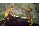
Dungeness Crab - Arthropods
(Metacarcinus magister)
(Metacarcinus magister)
Juvenile (YOY) Rockfish - Unidentified - Scorpionfish
(Sebastes sp. (YOY))
(Sebastes sp. (YOY))

Kelp Perch - Surfperch
(Brachyistius frenatus)
(Brachyistius frenatus)
Leather Star - Echinoderms
(Dermasterias imbricata)
(Dermasterias imbricata)

Longfin Gunnel - Gunnel
(Pholis clemensi)
(Pholis clemensi)

Quillback Rockfish - Scorpionfish
(Sebastes maliger)
(Sebastes maliger)

Red Rock Crab - Arthropods
(Cancer productus)
(Cancer productus)

Spiny Pink Star - Echinoderms
(Pisaster brevispinus)
(Pisaster brevispinus)
