Region: TWA
All
Survey Types: Species & Abundance, Species Only
Dates: 1/1/93 - 6/26/26
Total Surveys: 1
#Species Reported: 17
Average Species Reported on a Survey by Expert Surveyors: 0
Average Species Reported on a Survey by Novice Surveyors: 17.00
Survey Type: SA = Species & Abundance; SO = Species Only - How to interpret REEF data?
Click a column header to sort by that column. Hold shift and click to sort by multiple columns
| Surveys | Bottom Time | |||||
|---|---|---|---|---|---|---|
| Expert | Novice | |||||
| Code | Name | SA | SO | SA | SO | (H:M) |
| 4 | BAHAMAS, TURKS & CAICOS | 0 | 0 | 1 | 0 | 0:35 |
| 41 | NORTH BAHAMAS (N. of Providence Channel) | 0 | 0 | 1 | 0 | 0:35 |
| 4104 | Abaco Island | 0 | 0 | 1 | 0 | 0:35 |
| 41040038 | Great Guana Cay (NW most point - bankside) | 0 | 0 | 1 | 0 | 0:35 |
| TOTALS | 0 | 0 | 1 | 0 | 0:35 | |
Species
%SF = Sighting Frequency; DEN = Density Score - How to interpret REEF data?
Bar length corresponds to sighting frequency
Color saturation corresponds to density score
Click + to display species image and additional information.
Bar length corresponds to sighting frequency
Color saturation corresponds to density score
Click + to display species image and additional information.
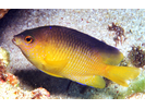
Beaugregory - Damselfish
(Stegastes leucostictus)
(Stegastes leucostictus)
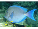
Blue Tang - Surgeonfish
(Acanthurus coeruleus)
(Acanthurus coeruleus)
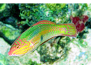
Bluehead - Wrasse
(Thalassoma bifasciatum)
(Thalassoma bifasciatum)
Bucktooth Parrotfish - Parrotfish
(Sparisoma radians)
(Sparisoma radians)
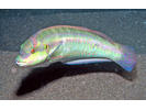
Clown Wrasse - Wrasse
(Halichoeres maculipinna)
(Halichoeres maculipinna)
Dusky Damselfish - Damselfish
(Stegastes adustus)
(Stegastes adustus)
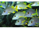
French Grunt - Grunt
(Haemulon flavolineatum)
(Haemulon flavolineatum)
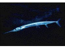
Houndfish - Needlefish
(Tylosurus crocodilus crocodilus)
(Tylosurus crocodilus crocodilus)
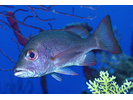
Mahogany Snapper - Snapper
(Lutjanus mahogoni)
(Lutjanus mahogoni)
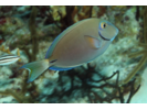
Ocean Surgeonfish - Surgeonfish
(Acanthurus tractus)
(Acanthurus tractus)
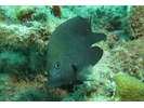
Sailors Choice - Grunt
(Haemulon parra)
(Haemulon parra)
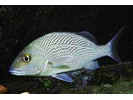
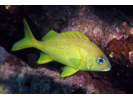
Schoolmaster - Snapper
(Lutjanus apodus)
(Lutjanus apodus)
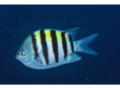
Sergeant Major - Damselfish
(Abudefduf saxatilis)
(Abudefduf saxatilis)
Slippery Dick - Wrasse
(Halichoeres bivittatus)
(Halichoeres bivittatus)
Squirrelfish - Squirrelfish
(Holocentrus adscensionis)
(Holocentrus adscensionis)

Unidentified Silvery Fish (Silversides / Anchovies / Herrings) - Silvery Fishes - Silversides, Herrings, and Anchovies
(Atheriniformes sp./ Clupeiformes sp.)
(Atheriniformes sp./ Clupeiformes sp.)

Yellow Goatfish - Goatfish
(Mulloidichthys martinicus)
(Mulloidichthys martinicus)
