Region: HAW
All
Survey Types: Species & Abundance, Species Only
Dates: 1/1/93 - 7/14/26
Total Surveys: 1
#Species Reported: 13
Average Species Reported on a Survey by Expert Surveyors: 13.00
Average Species Reported on a Survey by Novice Surveyors: 0
Survey Type: SA = Species & Abundance; SO = Species Only - How to interpret REEF data?
Click a column header to sort by that column. Hold shift and click to sort by multiple columns
| Surveys | Bottom Time | |||||
|---|---|---|---|---|---|---|
| Expert | Novice | |||||
| Code | Name | SA | SO | SA | SO | (H:M) |
| 4 | Maui County (Maui, Lanai, Molokai, and Kahoolawe) | 1 | 0 | 0 | 0 | 0:31 |
| 41 | Maui | 1 | 0 | 0 | 0 | 0:31 |
| 4101 | Leeward Shore Maui (Honolua Bay - Cape Hanamanoia) | 1 | 0 | 0 | 0 | 0:31 |
| 410102 | South Maui (McGregor Pt. - Cape Hanamanoia) | 1 | 0 | 0 | 0 | 0:31 |
| 41010281 | Kihei 483 | 1 | 0 | 0 | 0 | 0:31 |
| TOTALS | 1 | 0 | 0 | 0 | 0:31 | |
Species
%SF = Sighting Frequency; DEN = Density Score - How to interpret REEF data?
Bar length corresponds to sighting frequency
Color saturation corresponds to density score
Click + to display species image and additional information.
Bar length corresponds to sighting frequency
Color saturation corresponds to density score
Click + to display species image and additional information.
Blackspot Sergeant - Damselfish
(Abudefduf sordidus)
(Abudefduf sordidus)
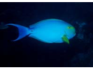
Brown Surgeonfish (aka Lavender Tang) - Surgeonfish
(Acanthurus nigrofuscus)
(Acanthurus nigrofuscus)

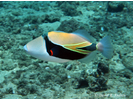
Convict Tang - Surgeonfish
(Acanthurus triostegus)
(Acanthurus triostegus)

Forcepsfish (aka Longnose Butterflyfish) - Butterflyfish
(Forcipiger flavissimus)
(Forcipiger flavissimus)
Hawaiian Sergeant - Damselfish
(Abudefduf abdominalis)
(Abudefduf abdominalis)

Manybar Goatfish - Goatfish
(Parupeneus multifasciatus)
(Parupeneus multifasciatus)
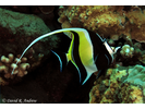
Moorish Idol - Moorish Idol
(Zanclus cornutus)
(Zanclus cornutus)
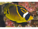
Raccoon Butterflyfish - Butterflyfish
(Chaetodon lunula)
(Chaetodon lunula)
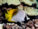
Threadfin Butterflyfish - Butterflyfish
(Chaetodon auriga)
(Chaetodon auriga)
Wedgetail Triggerfish (aka Reef Triggerfish) - Triggerfish
(Rhinecanthus rectangulus)
(Rhinecanthus rectangulus)
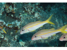
Yellowfin Goatfish - Goatfish
(Mulloidichthys vanicolensis)
(Mulloidichthys vanicolensis)
Yellowfin Surgeonfish - Surgeonfish
(Acanthurus xanthopterus)
(Acanthurus xanthopterus)
Yellowstripe Goatfish (aka Squarespot Goatfish) - Goatfish
(Mulloidichthys flavolineatus)
(Mulloidichthys flavolineatus)