Region: PAC
All
Survey Types: Fish Only, Invertebrates Only, Fish & Invertebrates
Dates: 1/1/93 - 7/15/26
Total Surveys: 4
#Species Reported: 19
Average Species Reported on a Survey by Expert Surveyors: 9.25
Average Species Reported on a Survey by Novice Surveyors: 0
Survey Type: FO = Fish Only; IO = Invertebrates Only; FI = Fish & Invertebrates - How to interpret REEF data?
Click a column header to sort by that column. Hold shift and click to sort by multiple columns
| Surveys | Bottom Time | |||||||
|---|---|---|---|---|---|---|---|---|
| Expert | Novice | |||||||
| Code | Name | FO | IO | FI | FO | IO | FI | (H:M) |
| 4 | California | 4 | 0 | 0 | 0 | 0 | 0 | 3:43 |
| 41 | NORTHERN CALIFORNIA | 4 | 0 | 0 | 0 | 0 | 0 | 3:43 |
| 4118 | S Point Buchon - N Point Sal | 4 | 0 | 0 | 0 | 0 | 0 | 3:43 |
| 41180001 | Pt. Buchon (about 1. mile south of) | 4 | 0 | 0 | 0 | 0 | 0 | 3:43 |
| TOTALS | 4 | 0 | 0 | 0 | 0 | 0 | 3:43 | |
Species
%SF = Sighting Frequency; DEN = Density Score - How to interpret REEF data?
Bar length corresponds to sighting frequency
Color saturation corresponds to density score
Click + to display species image and additional information.
Bar length corresponds to sighting frequency
Color saturation corresponds to density score
Click + to display species image and additional information.
Striped Seaperch - Surfperch
(Embiotoca lateralis)
(Embiotoca lateralis)

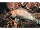
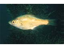
Blackeye Goby - Goby
(Rhinogobiops nicholsii)
(Rhinogobiops nicholsii)

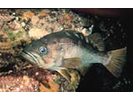
Blue Rockfish - generic ID - Scorpionfish
(Sebastes mystinus/diaconus)
(Sebastes mystinus/diaconus)

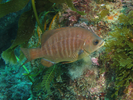
Gopher Rockfish - Scorpionfish
(Sebastes carnatus)
(Sebastes carnatus)
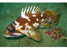
Kelp Rockfish - Scorpionfish
(Sebastes atrovirens)
(Sebastes atrovirens)
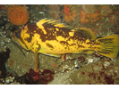
Painted Greenling - Greenling
(Oxylebius pictus)
(Oxylebius pictus)

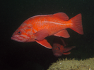
Black Rockfish - Scorpionfish
(Sebastes melanops)
(Sebastes melanops)
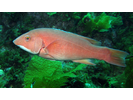
California Sheephead - Wrasse
(Bodianus pulcher)
(Bodianus pulcher)
Juvenile (YOY) Rockfish - Unidentified - Scorpionfish
(Sebastes sp. (YOY))
(Sebastes sp. (YOY))

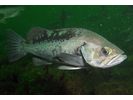
Lingcod - Greenling
(Ophiodon elongatus)
(Ophiodon elongatus)

Stripefin Ronquil (R. alleni) - Ronquil
(Rathbunella alleni)
(Rathbunella alleni)
Black Perch - Surfperch
(Embiotoca jacksoni)
(Embiotoca jacksoni)
Black-and-Yellow Rockfish - Scorpionfish
(Sebastes chrysomelas)
(Sebastes chrysomelas)
Canary Rockfish - Scorpionfish
(Sebastes pinniger)
(Sebastes pinniger)

Coralline Sculpin - Marine Sculpins
(Artedius corallinus)
(Artedius corallinus)

Kelp Perch - Surfperch
(Brachyistius frenatus)
(Brachyistius frenatus)
Olive Rockfish - Scorpionfish
(Sebastes serranoides)
(Sebastes serranoides)
Pile Perch - Surfperch
(Rhacochilus vacca)
(Rhacochilus vacca)

Vermilion Rockfish - Scorpionfish
(Sebastes miniatus)
(Sebastes miniatus)