Region: PAC
All
Survey Types: Fish Only, Invertebrates Only, Fish & Invertebrates
Dates: 1/1/93 - 6/29/26
Total Surveys: 5
#Species Reported: 20
Average Species Reported on a Survey by Expert Surveyors: 6.60
Average Species Reported on a Survey by Novice Surveyors: 0
Survey Type: FO = Fish Only; IO = Invertebrates Only; FI = Fish & Invertebrates - How to interpret REEF data?
Click a column header to sort by that column. Hold shift and click to sort by multiple columns
| Surveys | Bottom Time | |||||||
|---|---|---|---|---|---|---|---|---|
| Expert | Novice | |||||||
| Code | Name | FO | IO | FI | FO | IO | FI | (H:M) |
| 5 | Alaska | 0 | 0 | 5 | 0 | 0 | 0 | 3:46 |
| 56 | Southeast Alaska (Yakutat Bay to Canadian Border) | 0 | 0 | 5 | 0 | 0 | 0 | 3:46 |
| 5601 | Yakutat Bay to Pt. Bishop (including Juneau) | 0 | 0 | 5 | 0 | 0 | 0 | 3:46 |
| 56010002 | Princess Sophia, Vanderbilt Reef | 0 | 0 | 2 | 0 | 0 | 0 | 1:35 |
| 56010003 | Ann Coleman Wall | 0 | 0 | 1 | 0 | 0 | 0 | 0:45 |
| 56010007 | Lena Cove | 0 | 0 | 1 | 0 | 0 | 0 | 0:45 |
| 56010008 | Amalga Harbor - Kayak Ramp | 0 | 0 | 1 | 0 | 0 | 0 | 0:41 |
| TOTALS | 0 | 0 | 5 | 0 | 0 | 0 | 3:46 | |
Species
%SF = Sighting Frequency; DEN = Density Score - How to interpret REEF data?
Bar length corresponds to sighting frequency
Color saturation corresponds to density score
Click + to display species image and additional information.
Bar length corresponds to sighting frequency
Color saturation corresponds to density score
Click + to display species image and additional information.
Green Sea Urchin - Echinoderms
(Strongylocentrotus droebachiensis)
(Strongylocentrotus droebachiensis)

Coonstripe Shrimp - Arthropods
(Pandalus danae / gurneyi)
(Pandalus danae / gurneyi)

Sunflower Star - Echinoderms
(Pycnopodia helianthoides)
(Pycnopodia helianthoides)

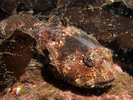
Buffalo Sculpin - Marine Sculpins
(Enophrys bison)
(Enophrys bison)
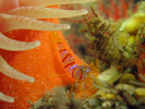
Candy Stripe Shrimp - Arthropods
(Lebbeus grandimanus)
(Lebbeus grandimanus)
Crescent Gunnel - Gunnel
(Pholis laeta)
(Pholis laeta)

Oregon Triton - Mollusks
(Fusitriton oregonensis)
(Fusitriton oregonensis)
Plumose Anemone - Cnidarians
(Metridium farcimen / senile)
(Metridium farcimen / senile)

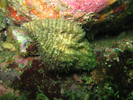
Tiger Rockfish - Scorpionfish
(Sebastes nigrocinctus)
(Sebastes nigrocinctus)

Black Rockfish - Scorpionfish
(Sebastes melanops)
(Sebastes melanops)
California Sea Cucumber - Echinoderms
(Parastichopus californicus)
(Parastichopus californicus)

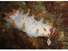
Clown Dorid - Mollusks
(Triopha modesta / Triopha catalinae)
(Triopha modesta / Triopha catalinae)
English Sole - Righteye Flounder
(Parophrys vetulus)
(Parophrys vetulus)
Kelp Greenling - Greenling
(Hexagrammos decagrammus)
(Hexagrammos decagrammus)

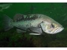
Lingcod - Greenling
(Ophiodon elongatus)
(Ophiodon elongatus)

Orange Sea Cucumber - Echinoderms
(Cucumaria miniata)
(Cucumaria miniata)

Quillback Rockfish - Scorpionfish
(Sebastes maliger)
(Sebastes maliger)

Rock Scallop - Mollusks
(Crassadoma gigantea)
(Crassadoma gigantea)

Shiny Orange Sea Squirt - Urochordates
(Cnemidocarpa finmarkiensis)
(Cnemidocarpa finmarkiensis)

Speckled Sanddab - Sand Flounder
(Citharichthys stigmaeus)
(Citharichthys stigmaeus)
