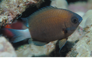
Chocolate Dip Damselfish - Damselfish (Pycnochromis hanui)
Seen in 41.93% of all REEF surveys in the HAW region.
Dates: 1/1/93 - 2/4/22
Region: HAW
Click a column header to sort by that column. Hold shift and click to sort by multiple columns
| Code | Name | N | Total | Expert | Novice | ||||||
|---|---|---|---|---|---|---|---|---|---|---|---|
| n | SF% | DEN | n | SF% | DEN | n | SF% | DEN | |||
| 1 | Northwest Hawaiian Islands | 91 | 30 | 32.97 | 2.75 | 0 | 0 | 0 | 30 | 33.71 | 2.75 |
| 1101 | Midway Atoll | 27 | 15 | 55.56 | 3.54 | 0 | 0 | 0 | 15 | 60 | 3.54 |
| 1201 | Kure Atoll | 49 | 11 | 22.45 | 2 | 0 | 0 | 0 | 11 | 22.45 | 2 |
| 1301 | Pearl and Hermes Atoll | 13 | 4 | 30.77 | 2.25 | 0 | 0 | 0 | 4 | 30.77 | 2.25 |
| 2 | Kauai (including Niihau Island) | 902 | 245 | 27.16 | 2.43 | 82 | 45.05 | 2.48 | 163 | 22.64 | 2.4 |
| 21 | Niihau Island and Lehua Island | 73 | 41 | 56.16 | 2.15 | 12 | 80 | 2.17 | 29 | 50 | 2.14 |
| 2101 | North Shore Niihau (Kaunuopou Pt. - north of Kawaihoa Pt.) | 30 | 20 | 66.67 | 2.1 | 4 | 100 | 2.25 | 16 | 61.54 | 2.06 |
| 2103 | Lehua Rock Island | 43 | 21 | 48.84 | 2.19 | 8 | 72.73 | 2.13 | 13 | 40.63 | 2.23 |
| 23 | North Coast Kauai (Kailiu Pt at Haena Beach Park. - Kepuhi Pt.) | 288 | 10 | 3.47 | 1.67 | 3 | 5.77 | 1.33 | 7 | 2.97 | 1.83 |
| 2301 | Kailiu Pt. - Kaweonui Pt. | 196 | 7 | 3.57 | 1.43 | 3 | 8.33 | 1.33 | 4 | 2.5 | 1.5 |
| 2302 | Kaweonui Pt. - Kepuhi Pt. | 92 | 3 | 3.26 | 2.5 | 0 | 0 | 0 | 3 | 3.95 | 2.5 |
| 25 | South Shore Kauai (Makahuena Pt. - Nohili Pt.) | 488 | 194 | 39.75 | 2.52 | 67 | 66.34 | 2.59 | 127 | 32.82 | 2.49 |
| 2501 | Makahuena Pt. - Puolo Pt. | 459 | 186 | 40.52 | 2.53 | 67 | 69.07 | 2.59 | 119 | 32.87 | 2.5 |
| 2502 | Puolo Pt. - Nohili Pt. | 29 | 8 | 27.59 | 2.25 | 0 | 0 | 0 | 8 | 32 | 2.25 |
| 3 | Oahu | 3023 | 256 | 8.47 | 1.95 | 67 | 6.11 | 1.15 | 189 | 9.81 | 2.18 |
| 31 | Leeward Side Oahu (Kaena Pt. - Diamond Head) | 865 | 119 | 13.76 | 2.15 | 15 | 16.67 | 1.8 | 104 | 13.42 | 2.17 |
| 3101 | Waianae Coast (Kaena Pt. - Barbers Pt.) | 221 | 64 | 28.96 | 2.2 | 10 | 43.48 | 0 | 54 | 27.27 | 2.2 |
| 3102 | Mamala Bay (Barbers Pt. - Diamond Head) | 644 | 55 | 8.54 | 2.09 | 5 | 7.46 | 1.8 | 50 | 8.67 | 2.12 |
| 32 | South Coast Oahu (E. of Diamond Head - Makapuu Pt.) | 981 | 53 | 5.4 | 2.14 | 0 | 0 | 0 | 53 | 6.04 | 2.14 |
| 3201 | Maunalua Bay | 113 | 33 | 29.2 | 2.03 | 0 | 0 | 0 | 33 | 31.73 | 2.03 |
| 3202 | Kawaihoa Pt. - Makapuu Pt. (incl. Hanauma Bay) | 866 | 20 | 2.31 | 2.3 | 0 | 0 | 0 | 20 | 2.59 | 2.3 |
| 33 | Windward Side Oahu (Makapuu Pt. - Kahuku Pt.) | 963 | 53 | 5.5 | 1.08 | 52 | 6.12 | 1.08 | 1 | 0.88 | 0 |
| 3301 | Kaneohe Bay (Makapuu Pt. - Kualoa Pt.) | 957 | 53 | 5.54 | 1.08 | 52 | 6.14 | 1.08 | 1 | 0.91 | 0 |
| 34 | North Shore Oahu (W. of Kahuku Pt. - Kaena Pt.) | 214 | 31 | 14.49 | 2.31 | 0 | 0 | 0 | 31 | 19.38 | 2.31 |
| 3401 | Kahuku Pt. - Puaena Pt. (north end of Waialua Bay) | 209 | 31 | 14.83 | 2.31 | 0 | 0 | 0 | 31 | 19.5 | 2.31 |
| 4 | Maui County (Maui, Lanai, Molokai, and Kahoolawe) | 8397 | 3336 | 39.73 | 2.4 | 977 | 50.57 | 2.48 | 2359 | 36.49 | 2.37 |
| 41 | Maui | 7559 | 2903 | 38.4 | 2.39 | 824 | 51.44 | 2.45 | 2079 | 34.9 | 2.36 |
| 4101 | Leeward Shore Maui (Honolua Bay - Cape Hanamanoia) | 6976 | 2468 | 35.38 | 2.31 | 677 | 47.34 | 2.34 | 1791 | 32.29 | 2.3 |
| 4102 | Molokini Shoal MLCD | 483 | 375 | 77.64 | 2.9 | 129 | 87.76 | 3.01 | 246 | 73.21 | 2.84 |
| 4103 | South Shore Maui (Cape Hanamanoia - Nanualele Pt. at Hana Bay) | 48 | 35 | 72.92 | 2.51 | 13 | 81.25 | 2.54 | 22 | 68.75 | 2.5 |
| 4104 | Windward Coast Maui (Nanualele Pt. at Hana Bay - Nakalele Pt.) | 41 | 22 | 53.66 | 2.18 | 5 | 55.56 | 2.2 | 17 | 53.13 | 2.18 |
| 42 | Lanai | 770 | 420 | 54.55 | 2.5 | 148 | 46.25 | 2.61 | 272 | 60.44 | 2.43 |
| 4201 | East Coast Lanai (Kamaiki Pt. - Hale o Lono) | 19 | 14 | 73.68 | 2.1 | 1 | 100 | 2 | 13 | 72.22 | 2.11 |
| 4202 | West Coast Lanai (Hale o Lono - Palaoa Pt.) | 91 | 46 | 50.55 | 2.27 | 20 | 47.62 | 2.25 | 26 | 53.06 | 2.29 |
| 4203 | South Side Lanai (Palaoa Pt. - Kamaiki Pt.) | 660 | 360 | 54.55 | 2.54 | 127 | 45.85 | 2.67 | 233 | 60.84 | 2.46 |
| 43 | Molokai | 59 | 12 | 20.34 | 2.67 | 4 | 80 | 3.25 | 8 | 14.81 | 2.38 |
| 4301 | Mokuhooniki Island | 9 | 7 | 77.78 | 2.86 | 4 | 80 | 3.25 | 3 | 75 | 2.33 |
| 4302 | South Side Molokai not incl. Mokuhooniki Isl. (Halava - Loau Pt.) | 13 | 5 | 38.46 | 2.4 | 0 | 0 | 0 | 5 | 38.46 | 2.4 |
| 44 | Koholawe | 9 | 1 | 11.11 | 0 | 1 | 20 | 0 | 0 | 0 | 0 |
| 4401 | Kaho'olawe (north of Ule Pt. - Kealaikahiki Pt.) | 5 | 1 | 20 | 0 | 1 | 20 | 0 | 0 | 0 | 0 |
| 5 | Hawaii (The Big Island) | 9132 | 5379 | 58.9 | 2.35 | 3489 | 63.77 | 2.28 | 1890 | 51.63 | 2.49 |
| 51 | Kohala Coast Big Island (Upolu Pt. - Keahole Pt.) | 1437 | 1028 | 71.54 | 2.23 | 725 | 84.2 | 2.17 | 303 | 52.6 | 2.37 |
| 5101 | North Kohala Coast (Upolu Pt. - Kawaihae Harbor) | 303 | 265 | 87.46 | 2.25 | 167 | 97.66 | 2.29 | 98 | 74.24 | 2.2 |
| 5102 | South Kohala Coast (Kawaihae Harbor - Keahole Pt.) | 1134 | 763 | 67.28 | 2.22 | 558 | 80.87 | 2.13 | 205 | 46.17 | 2.45 |
| 52 | Kona Coast (Keahole Pt. - Ka Lae/South Pt.) | 6049 | 4332 | 71.62 | 2.38 | 2759 | 81.87 | 2.3 | 1573 | 58.72 | 2.52 |
| 5201 | North Kona Coast (Keahole Pt. - Cook Pt./N. side of Kealakekua Bay) | 4848 | 3700 | 76.32 | 2.36 | 2615 | 85.68 | 2.32 | 1085 | 60.41 | 2.47 |
| 5202 | South Kona Coast (Cook Pt./Kealakekua Bay - Ka Lae/South Point) | 1201 | 632 | 52.62 | 2.48 | 144 | 45.28 | 1.99 | 488 | 55.27 | 2.64 |
| 53 | South Coast Big Island (Ka Lae/S. Point - Kipu Pt. at N. side of Cape Kumukahi) | 37 | 1 | 2.7 | 2 | 0 | 0 | 0 | 1 | 2.94 | 2 |
| 5301 | Ka Lae - Kapaoo Pt. | 7 | 1 | 14.29 | 2 | 0 | 0 | 0 | 1 | 16.67 | 2 |
| 54 | East Corner Big Island incl. Hilo (Kipu Pt. - Pepeekeo Pt.) | 1609 | 18 | 1.12 | 2 | 5 | 0.4 | 1.8 | 13 | 3.49 | 2.08 |
| 5402 | n. of Leleiwi Pt. - Pepeekeo Pt. | 1609 | 18 | 1.12 | 2 | 5 | 0.4 | 1.8 | 13 | 3.49 | 2.08 |